Welcome
Lexington has a park system you've never visited.
You know the first one — the green shapes on this map. Jacobson. Masterson Station. Shillito. 109 parks you can walk into.
This guide is about the second one: 36 parcels of recorded greenway that appear on every map as open space, are assessed as open space, and are taxed at approximately $0 as open space — but belong to homeowners' associations and development companies. They are parks in every sense except the one where you're allowed in.
The system
36 parcels. 114.9 acres. 0 visitors.
Here they are. Since the 1990s, subdivision plats have carved greenway lots along Lexington's creeks and floodplains — then handed them to HOAs and LLCs instead of the city.
We have organized them, as any self-respecting park system would, into eight parks. Each has a name, an acreage, and visitor information. The visitor information is always the same.
Tier 1 — must be deeded to the city on request Tier 2 — deeded on mutual agreement Tier 3 — detention / transfer mechanics Tier 4 — stated intent only Tier 5 — no mechanism at all
How this happened
It's written on the plats.
This is the recorded plat for the largest parcel in the system — 19.7 acres on Sperling Drive, filed by Ball Homes in 2010. Note 7 promises a shared-use trail. Note 10 says the greenway "shall be dedicated to the LFUCG" and that the owner "shall dedicate the property to LFUCG upon request by LFUCG."
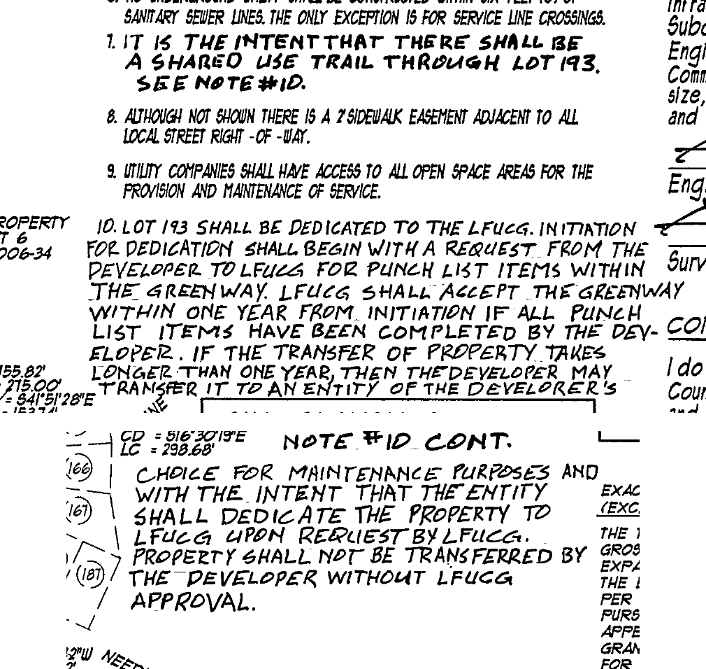
The request has never been made. The same clause, from the same developer, appears across the Chilesburg, Blackford and Sunny Slope plats. Other plats use softer language; some use none. That's the tier system.
Trail map
We've taken the liberty of drawing the trails.
A park system needs a trail map, so this one now has a proposed one. Each line links the parcels of a park to each other and to the nearest public trail or park, routed the way a trail planner would: along creeks, across public greenway, through the fields and open ground in between — and, when there is no better option, briefly down a sidewalk.
Where two parcels could only be joined by a long walk through a subdivision, we left them unjoined. Farmland and open ground were fair game — that is where trail easements have always come from.
Visitor information
48.7 acres could open with a letter.
Seventeen of these parcels — highlighted now — sit under plat language that says the owner shall dedicate the land to LFUCG upon request by LFUCG.
The request is the entire mechanism. No purchase. No condemnation. No ballot measure. A letter.
This site makes no recommendation. It is merely a visitor's guide, for parks that cannot have visitors.